

|
|
|
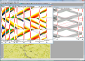
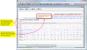
Time-Space or Platoon-Progression diagrams on Intersecting Arteries!
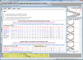
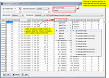
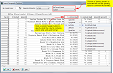
Comparative Travel Time & Delay Reports from GPS Travel Time Runs!
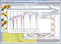
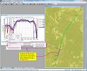
Speed-Distance Plots from GPS Runs!
Connect the Dots to create a Signalized Network!
Import Trip Logs with a flexible, customizable Import Previewer, including factory presets for common file formats!
Import Geographic Positions with a flexible, customizable Import Previewer!
Minimize the Transition between Timing Plans!
Shift Selected Offsets or All Offsets Network Wide while preserving Coordination!
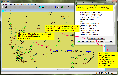
Color-Coded Links on Network View summarize Average Link Speed!
Color-Coded Trip Log Points on Network View show Instantaneous Speed!
Travel Time & Delay Report has split panels to keep the column headers in view while you scroll through the report!